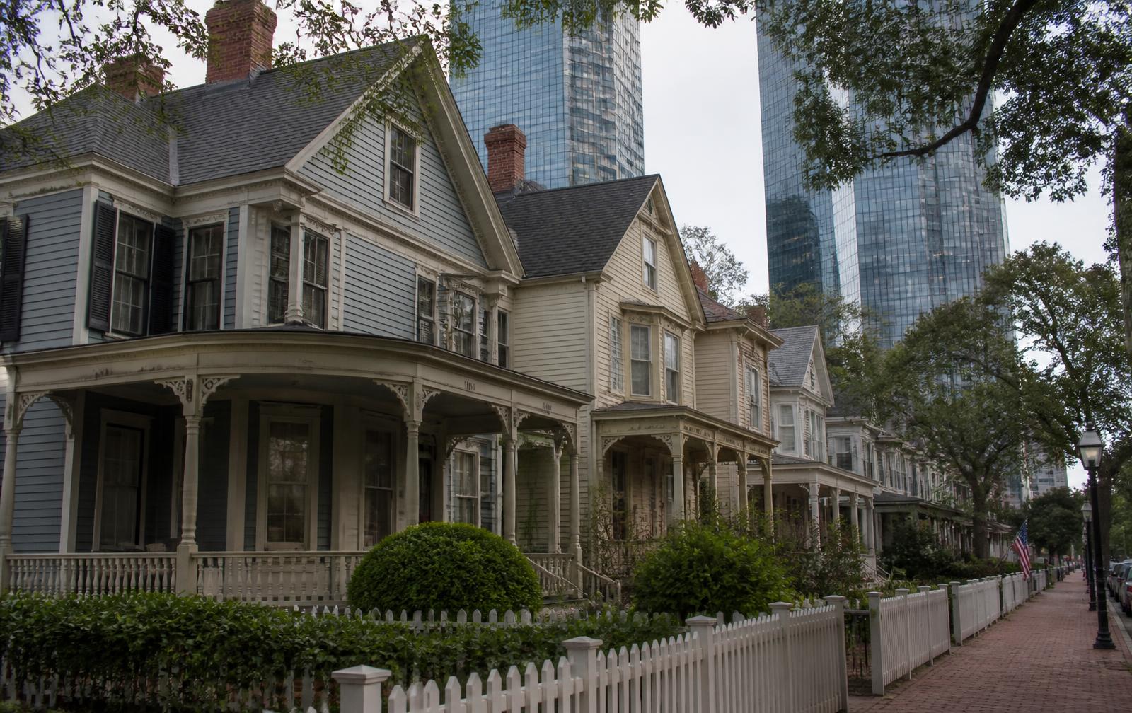
Historic and modern architecture side by side in Uptown Charlotte

How we got here

History of Uptown Charlotte & the four wards

From a colonial crossroads at Trade and Tryon to a four-ward city plan, the gold and cotton economies, urban renewal in Brooklyn, the 1970s Fourth Ward revival, and the banking skyline that followed.

Four wards, drawn at a crossroads

Charlotte began where two Native American trading paths crossed. Those paths became Trade Street and Tryon Street, and the point where they meet — Independence Square — is still the origin of the ward system that divides Uptown into four quadrants.

Everything Uptown is today, including which quadrant kept its old houses and which lost them, traces back to decisions made at that intersection.

Charlotte incorporated
1768
Wards laid out in the 1850s
4
Brooklyn cleared by urban renewal
1960s
Fourth Ward revival begins
1970s

01

The crossroads and the ward plan

The town grew outward from the Trade and Tryon crossing, and by the mid-nineteenth century the four quadrants around it were formalized as First, Second, Third and Fourth wards — a numbering that runs counterclockwise and still governs how residents describe where they live.

The wards were political units first, with their own representation, and residential neighborhoods second. That dual identity is why the boundaries survived long after the political function disappeared.

02

Gold, cotton, and the railroad

Charlotte's first boom came from gold, with a branch United States Mint opening in the 1830s. Cotton and the railroads followed, turning the crossroads town into a regional processing and shipping center by the late nineteenth century.

That economy built the mill housing and the merchant houses, a handful of which survive today only in Fourth Ward.

03

Brooklyn and urban renewal

Second Ward was home to Brooklyn, the center of Black civic, business and church life in Charlotte for generations, with Second Ward High School at its heart. Federal urban renewal programs cleared it in the 1960s and early 1970s, displacing thousands of residents and hundreds of businesses.

The land became government buildings, parking and eventually the Convention Center. Understanding Second Ward — including the Brooklyn Village redevelopment now planned there — requires understanding what was removed first.

04

The Fourth Ward revival

In the 1970s a coalition of preservationists, lenders and city officials took the opposite approach in Fourth Ward, restoring Victorian houses instead of clearing them and creating the historic district that still defines the quadrant.

The contrast between Second Ward and Fourth Ward is the single most instructive fact in Uptown Charlotte's history: two adjacent quadrants, two opposite policies, two completely different places today.

05

The banking skyline

Charlotte's emergence as a national banking center in the 1980s and 1990s produced the towers that now define the skyline, and with them the office population that supports Uptown's restaurants, hotels and stadiums.

Residential high-rise followed the offices, and it is that residential layer — condominiums, converted lofts and apartment towers — that turned Uptown from a nine-to-five district into a neighborhood.

Questions & Answers

Frequently asked questions

Direct answers to what readers most often ask about this part of Uptown. Each answer cites the primary source it rests on.

All Uptown Charlotte questions →

Why is Uptown Charlotte called Uptown instead of downtown?

+

The center of Charlotte sits on a ridge, so travelers historically went up to reach it, and the city adopted 'Uptown' as its formal branding for the center city inside the I-277 loop. The four wards are the historic subdivisions of that same area.

Source: Charlotte Center City Partners — State of the Center City

How were the four wards of Charlotte created?

+

The wards were laid out in the mid-nineteenth century as political subdivisions radiating from Independence Square, the intersection of Trade and Tryon streets, which itself formed where two Native American trading paths crossed.

Source: City of Charlotte

What happened to the Brooklyn neighborhood in Second Ward?

+

Brooklyn was the heart of Black Charlotte until federal urban renewal cleared it in the 1960s and early 1970s, displacing thousands of residents and hundreds of businesses and demolishing Second Ward High School. The Brooklyn Village redevelopment now planned on that land is the subject of ongoing public discussion.

Source: Charlotte-Mecklenburg Schools school locator

Why does Fourth Ward still have Victorian houses?

+

A 1970s preservation-led revival restored Fourth Ward's nineteenth-century houses instead of clearing them, creating the historic district that survives beneath the modern towers. Many of those parcels are subject to local historic district review.

Source: Mecklenburg County POLARIS 3G parcel viewer

Topic Cluster

The Four Wards of Uptown Charlotte

First, Second, Third and Fourth Ward — four quadrants, four completely different places.

The Uptown Guide — The Four Wards of Uptown Charlotte

Our Sources

How this page was researched

This guide is independently written and verified against primary public records and official organizations. It is not affiliated with, endorsed by, or representing the City of Charlotte, Charlotte Center City Partners, any condominium association, or any building owner.

Read our full citation methodology and editorial standards
  1. 01
    Local history collections and archives

    Charlotte Mecklenburg Library — Robinson-Spangler Carolina Room

    Ward history, the Brooklyn neighborhood, and urban renewal record.

  2. 02
    Local historic districts and designated landmarks

    Charlotte-Mecklenburg Historic Landmarks Commission

    Fourth Ward historic district and individually designated buildings.

  3. 03
    State of the Center City report and development pipeline

    Charlotte Center City Partners

    Residential population, office inventory, and project pipeline for Uptown.

  4. 04
    Charlotte visitor and neighborhood guides

    Charlotte Regional Visitors Authority

    Dining, museums, events, and things to do inside the loop.

Figures such as pricing, dues, assessments, tenancy, and school assignment change over time. Always confirm current details directly with the source before making a decision.

Corrections

Found something out of date?

Buildings change hands, restaurants close, dues get restated, and boundaries move. If something on this page is wrong, tell us what and point to the record — corrections are reviewed against primary sources and published with the page's revision date.

Send correction